| |

|
 |
On SD Memory Card BlueChart g2 Vision offers the same rich detailed charting of BlueChart g2 to help you get the most out of your unit. In addition, g2 Vision features a growing database of high-resolution satellite imagery, above and below the water 3D p
Read more 
|
|
 |
| |

|
|
Canada LakeVü™ HD - microSD™/SD™ f/GPSMAP® Series, Montana® & Oregon® HandheldsWith maps of more than 6, 000 Canadian lakes - many with 1 foot contours throughout - this high definition-mapping product brings new levels o
Read more
|
|
|
| |

|
|
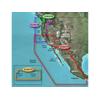
Detailed coverage of the West coast of North America from Vancouver, Can. to the U.S. border with Mexico. Detailed coverage includes Puget Sound, San Francisco Bay, San Diego Harbor, the Columbia and Snake Rivers, and the California Delta to Sacramento an
Read more
|
|
|
| |

|
|
Garmin B744VL Long Stem Bronze Thru-Hull Depth/Temp/Speed with FB - 8 Pin
Read more
|
|
|
| |

|
|
See your surroundings more clearly with BlueChart g2 data. With BlueChart g2, you\'ll get detailed marine cartography that provides convenient viewing of nautical content. BlueChart g2 allows you to see your vessel\'s precise, on-chart position in...
Read more
|
|
|
| |
|
|
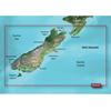
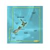
Maps & Add-Ons . VPC417S Covers: Includes the entire coast of the South Island, including the Bounty Islands to the southeast and Snares islands to the southwest; also includes the southernmost part of the North Island, from Foxton Beach to Cape Turnagain
Read more
|
|
|
| |

|
|
gWind™ Transducer OnlyThe gWind transducer features twin-fin technology with 3-bladed propeller for more accurate TWS in lighter air while the twin-fin design gives a more stable TWA. The 3-bladed propeller, unlike a cups design, is always efficient
Read more
|
|
|
| |

|
|
Garmin g2 HXAE003R Taiwan MicroSD and SD card see your vessels precise, on-chart position in relation to navaids, coastal features, anchorages, obstructions, waterways, restricted areas and more with this detailed marine mapping data. Also includes Safety
Read more
|
|
|
| |

|
|
HXAE006R Covers:General coverage of the coasts of Indonesia east of Sulawesi, northern Papua New Guinea, and the Solomon Islands. Included in this overall general coverage are numerous detailed charts covering areas such as Ternate, Indon., Lae, ...
Read more
|
|
|
| |

|
|
010-C0877-20 Garmin Bluechart G2 Hxae002R Yellow Sea Microsd & Sd HXAE002R Covers: General coverage of the Chinese coast from Wenzhou to Dandong, the North and South Korean coasts in their entirety, and the Russian coast east to Nakhodka. Also includes ge
Read more
|
|
|
| |
|
|
Garmin Bluechart G2 Vision, Vus401s, Bermuda, Micro/sd . Get a Fresh Perspective Get a fresh perspective when you take to the water with BlueChart g2 Vision. With BlueChart g2 Vision data, you ll get detailed marine cartography that provides convenient vi
Read more
|
|
|
| |
|
|
On SD Memory Card BlueChart g2 Vision offers the same rich detailed charting of BlueChart g2 to help you get the most out of your unit. In addition, g2 Vision features a growing database of high-resolution satellite imagery, above and below the water 3D p
Read more
|
|
|
| |
|
|
Plug a BlueChart g2 Vision SD data card into your chartplotter, and youll get a whole new perspective on nautical navigation. BlueChart g2 Vision offers the same rich detailed charting of BlueChart g2 to help you get the most out of your unit. In addition
Read more
|
|
|
| |
|
|
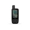
Navigate your next outdoor adventure with the GPSMAP 66 series. Whether you're hiking, hunting, climbing, geocaching, kayaking or mountain biking, you can explore more with this premium, rugged handheld with a 3" color display. It features access to...
Read more
|
|
|
| |

|
|
Enhance your boats marine instrumentation capabilities. This versatile thru-hull sensor provides depth and water temperature data and sends it to your NMEA 0183 Garmin digital marine instrument display or chartplotter.
Read more
|
|
|
| |

|
|
Included in this overall general coverage are numerous detailed charts covering areas such as the Indonesian cities of Jakarta, Semarang, and Ujungpandang, Manila, Phil., Kota Kinabalu, Mal., and Bandar Seri Begawan, Brun. Detailed coverage of the Mariana
Read more
|
|
|
| |
|
|
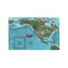
product : garmin bluechart g2 hxus039r us g2 (entire us) microsd & manufacturer : garmin charts manufacturer part no : 010-c1018-20.
Read more
|
|
|
| |
|
|
Coverage of the Pacific Ocean from the Hawaiian to Mariana Islands. Includes coverage of Guam, Midway, and Johnston Atoll. General coverage of Palmyra Atoll and the Marshall Islands also included.
Read more
|
|
|
| |
|
|
HXAE004R Covers:General coverage of the coasts of the Malay Peninsula, Thailand, Cambodia, Vietnam, and China east to Quanzhou, including Hainan Island and Macau. Included in this overall general coverage are numerous detailed charts covering areas...
Read more
|
|
|
| |

|
|
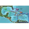
HXUS031R Covers:Detailed coverage of the northern coast of Central America from Cancun, Mexico to Barranquilla, Colombia, including the Panama Canal in its entirety. General coverage of the northern half of the Gulf of Panama. Also includes detailed...
Read more
|
|
|
| |

|
|
See your surroundings more clearly with BlueChart g2 data. With BlueChart g2, you'll get detailed marine cartography that provides convenient viewing of nautical content. BlueChart g2 allows you to see your vessel's precise, on-chart position in...
Read more
|
|
|
| |
|
|
HXUS029R Covers:FEATURING DATA FROM EXPLORER CHARTS FOR THE BAHAMAS!!! Detailed coverage from Eleuthera Island, Bahamas to the Dominican Republic
Read more
|
|
|


 Switch to grid view