| |
|
 |
GARMIN 010-C1098-00 Topo U.S. 100K MicroSD Card/SD Card• Microsd(Tm)Card/Sd(Tm) Card Map Update• Updated Topographical Coverage For The Us, Including Alaska, Hawaii & Puerto Rico• New Non-Routable Navteq(Tm) Content• Improved Cover
Read more 
|
|
 |
| |

|
|
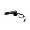
gWind™ Transducer OnlyThe gWind transducer features twin-fin technology with 3-bladed propeller for more accurate TWS in lighter air while the twin-fin design gives a more stable TWA. The 3-bladed propeller, unlike a cups design, is always efficient
Read more
|
|
|
| |
|
|
Garmin B175L Bronze 20 Degree Thru-Hull Transducer - 1kW, 8-Pin
Read more
|
|
|
| |
|
|
BlueChart g2 Vision offers the same rich detailed charting of BlueChart g2 to help you get the most out of your unit. In addition, g2 Vision features a growing database of high-resolution satellite imagery, above and below the water 3D perspective, auto g
Read more
|
|
|
| |

|
|
Read more
|
|
|
| |

|
|
Garmin g2 HXAE003R Taiwan MicroSD and SD card see your vessels precise, on-chart position in relation to navaids, coastal features, anchorages, obstructions, waterways, restricted areas and more with this detailed marine mapping data. Also includes Safety
Read more
|
|
|
| |
|
|
On SD Memory Card Plug a BlueChart g2 Vision SD data card into your chartplotter, and youll get a whole new perspective on nautical navigation. BlueChart g2 Vision offers the same rich detailed charting of BlueChart g2 to help you get the most out of your
Read more
|
|
|
| |

|
|
Garmin B175H Bronze 12 Degree Thru-Hull Transducer - 1kW, 8-Pin
Read more
|
|
|
| |
|
|
product : garmin bluechart g2 hxus039r us g2 (entire us) microsd & manufacturer : garmin charts manufacturer part no : 010-c1018-20.
Read more
|
|
|
| |
|
|
HXAE004R Covers:General coverage of the coasts of the Malay Peninsula, Thailand, Cambodia, Vietnam, and China east to Quanzhou, including Hainan Island and Macau. Included in this overall general coverage are numerous detailed charts covering areas...
Read more
|
|
|
| |
|
|
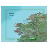
VEU484S Covers:Detailed coverage of Northwestern Ireland from Londonderry to Galway Bay. Also includes detailed coverage of Sligo, Ballina, Galway, and Donegal Bay.3-D View = Yes | Aerial Photos = Yes | Port Plans = Yes | Card Format = SD
Read more
|
|
|
| |

|
|
Canada LakeVü™ HD - microSD™/SD™ f/GPSMAP® Series, Montana® & Oregon® HandheldsWith maps of more than 6, 000 Canadian lakes - many with 1 foot contours throughout - this high definition-mapping product brings new levels o
Read more
|
|
|
| |

|
|
Plug a BlueChart g2 Vision SD data card into your chartplotter, and youll get a whole new perspective on nautical navigation. BlueChart g2 Vision offers the same rich detailed charting of BlueChart g2 to help you get the most out of your unit. In addition
Read more
|
|
|
| |

|
|
Garmin B175M Bronze 20 Degree Thru-Hull Transducer - 1kW, 8-Pin
Read more
|
|
|
| |

|
|
Included in this overall general coverage are numerous detailed charts covering areas such as the Indonesian cities of Jakarta, Semarang, and Ujungpandang, Manila, Phil., Kota Kinabalu, Mal., and Bandar Seri Begawan, Brun. Detailed coverage of the Mariana
Read more
|
|
|
| |
|
|
With Garmin''s NMEA 2000 Fluid Level Analog Adapter aboard your vessel, you can give new life to your old gauges by making the transition from analog to digital. This simple-to-install adapter takes the data generated by traditional analog gauges and conv
Read more
|
|
|
| |
|
|
GRF™ 10 - Rudder Feedback SensorCompatible DevicesPair this sensor with the GHP 12™ to provide rudder position feedback and to detect and avoid rudder stops while sailing or boating.The GRF 10 uses a magnetic sensor to relay position information
Read more
|
|
|
| |

|
|
VUS038R Covers: Coverage of Raritan Bay to Virginia Beach including Tarrytown Fire Island Inlet the entire New Jersey coastline the C D Canal Delaware Bay the Delaware River to Trenton Chesapeake Bay Baltimore the Potomac River to Washington D.C. Chincote
Read more
|
|
|
| |
|
|
Airmar P66 200/50kHz Plastic Transom Mount Transducer (8-pin)010-10192-21Our plastic, transom mount transducer provides depth, speed and temperature data. This transducer has an operating frequency of 50 or 200 kHz and mounts on a 2-20° transom angle
Read more
|
|
|
| |

|
|
Garmin P19 Nylon 20 Degree Tilt Transducer - 8-Pin
Read more
|
|
|
| |

|
|
010-C0877-20 Garmin Bluechart G2 Hxae002R Yellow Sea Microsd & Sd HXAE002R Covers: General coverage of the Chinese coast from Wenzhou to Dandong, the North and South Korean coasts in their entirety, and the Russian coast east to Nakhodka. Also includes ge
Read more
|
|
|
| |

|
|
Garmin VEU003R - Great Britain, Northeast Coast - SD Card
Read more
|
|
|
| |
|
|
Garmin Bluechart G2 Vision, Vus401s, Bermuda, Micro/sd . Get a Fresh Perspective Get a fresh perspective when you take to the water with BlueChart g2 Vision. With BlueChart g2 Vision data, you ll get detailed marine cartography that provides convenient vi
Read more
|
|
|
| |

|
|
Garmin GRF 10 Extension Cable - 15M
Read more
|
|
|


 Switch to grid view